
by S. Prasad Ganti
A recent news item piqued my interest. The National Air and Space Museum in Washington DC opened 5 new galleries. In the “Boeing milestones of flight hall”, etched on the floor is a set of radial lines emanating from a central point. This is the Pulsar map. It is a map showing the bearings of our planet earth with respect to 14 known pulsars, some in our galaxy and some outside. Pulsars are spinning remnants of once massive stars. These emit pointed beams of radio waves which is what the radial lines in the map represent.
Stars end their lives and become smoldering remains of once glowing nuclear furnaces. Smaller stars like our Sun become white dwarfs after death. While massive stars become neutron stars and black holes. Neutron stars are very dense objects where the electrons and protons of all the matter collapse into neutrons. Some neutron stars spin very rapidly and emit radio waves in focused beams from their poles. These neutron stars are known as pulsars. Something like light beams coming from a light house. Not all neutron stars have their beams coming towards earth. Some of them do. And 14 of them were selected to guide any alien to make the trip to the earth ! The picture below, courtesy National Air and Space Museum, shows the pulsar map on the floor. All the radial lines are not equal in length. The length indicates the distance of earth from the given pulsar.

The Pulsar map is very similar to the earlier navigation used by airplanes in our skies. There are a number of special radio sources installed on the ground, which transmit 360 different radio signals to indicate the 360 degrees of the direction from the source. Airplanes have specialized radio receivers which can receive these signals and specify which radial the plane is currently on. Similarly, another radial from another source can specify radial with respect to the second source. The intersection of the two radials provides the location of the airplane. Now, this is supplanted to a large extent by GPS navigation which works everywhere on the earth, even where there are no radio transmitters.
How do we know how far the pulsars are ? The spinning pulsars send radio waves. The pulse period, related to the frequency of the emitted radio waves, indicates the distance from the earth.
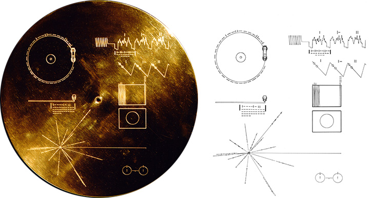
NASA launched 2 spacecraft Voyager 1 and Voyager 2 in the 1970s to make a grand tour of the outer gaseous planets – Jupiter, Saturn, Uranus, Neptune. And then they made their way across the outer solar system to interstellar space. A memento called “Voyager golden record” created by a committee led by famous astronomer Carl Sagan was put on these 2 spacecraft. A gold-plated phonograph record which contains images, greetings in 55 languages, diverse music, sounds of earth, and the Pulsar map. The Pulsar map itself was designed by Carl Sagan and another famous astronomer Frank Drake. These spacecraft also carry the needle used to play the golden record ! Any such modern day spacecraft would carry USB memory sticks instead ! The picture below, courtesy NASA, shows the details of the golden record.
The Pulsar map is not a static image which can ensure accuracy for centuries. Things keep changing all the time. Pulsars move. Our solar system moves around the center of our galaxy. An older version of the Pulsar map was sent on Pioneer 10 and Pioneer 11 spacecraft, which predated the Voyagers. What we have in the museum is the latest version, even later than what went on Voyager.
The museum is getting a lot of face lift. Some more galleries are coming up next year. It will be time to make the pilgrimage again !

